WildCats office blog – we are blessed to be based in an institution where visiting academics, scientists and conservationists are invited to talk about their work.

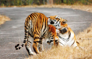
Radio collared tiger in Tadoba Andhari Tiger Reserve © Pallavi Ghaskadbi
Last week, I went to a fascinating talk at the Institute of Zoology here at ZSL, by Dr Bilal Habib scientist from the Wildlife Institute of India, who was talking about his research on the movement of animals including tigers, wolves and dhole in India.
His tiger work, using GPS radio collars and activity sensors, focuses on the movement of young subadult tigers which are collared between the age of 10-24 months and followed constantly.
The research has thrown up differences in behaviour of animals living in human dominated landscapes to those living in protected areas. Data shows animals daily activity patterns in the protected areas of rest during the day and activity at dawn and dusk as one might expect. Those animals living outside the national park however, move more at night and travel further in a shorter period of time. This will use more energy as they have less chance to rest and so need to feed, and perhaps predate on livestock more often. Evidence suggests that these animals also abandon prey due to human disturbance rather more than those animals in protected habitat that can return to eat.
Research shows that age of dispersal of young animals – the riskiest time of a tigers life, depends on the tiger density of an area. Where tiger numbers are higher young animals are forced to disperse earlier as they have more chance to get away from other local competitive males. Lower density areas are less risky. According to Dr Habib, young tigers are more likely to disperse into unprotected landscapes after the monsoon when crops and foliage give the best cover.
Data provided by these collars and activity sensors also suggests that female tigers constantly patrol to protect their territories. They walk shorter distances than males but are on the move for longer.
Following the movement of tigers, especially in a human dominated landscape, such as the area being studied by Dr Habib, can really help with land use management and conflict mitigation measures. Looking at the visual representation of the data on a map really did show very clearly the corridors used by the animals in this study. By overlaying the night-time density maps on the tiger routes, the pinch points of high human population and tiger movement were identified. This evidence can then influence government policies and intervention. One of the threats highlighted by this study is the number of electrocution of animals by farmers mains powers crop protection from pigs and deer. The data provided by Dr Habib can identify the villages where solar power electric fencing alternatives would have the best impact.
It’s great to hear first hand, from scientists working out in the field how their research is helping protect tigers in the wild.
Esther Conway
You can read more about Dr Habib on this article from the Times of India and see his biography and published work here at Loop

